• Skip to main content
  • Skip to secondary menu
  • Skip to footer
  • Home
  • Current/Back Issues
    • Hometown News Current Issue
    • Hometown News Past Issues
  • Obituaries
  • Local News
    • Local News
    • Obituaries
    • Local Minutes
    • Church Page
  • About Us/Links
    • Submit Classified Ad
      • Submit Classified Ad For The Paper
    • Submit Upcoming Event
    • Upload A Photo
    • Facebook
    • Twitter
    • Youtube Channel
    • Hometown News About Us
    • Custom Printing
    • Web Hosting
    • Website Templates
    • Subscription Form
    • Current Issue
    • Past Issues
  • Log in
    • Register
    • Log in
    • Reset Password
    • Lost Password
Hometown News • Grey Eagle – Upsala – Swanville – Burtrum – Freeport – Holdingford – Albany – Melrose – St. Rosa – Long Prairie – New Munich – Avon

Hometown News • Grey Eagle - Upsala - Swanville - Burtrum - Freeport - Holdingford - Albany - Melrose - St. Rosa - Long Prairie - New Munich - Avon

Serving Central Minnesota • Morrison County • Stearns County • Todd County

  • Home
  • Current/Back Issues
    • Hometown News Current Issue
    • Hometown News Past Issues
  • Obituaries
  • Local News
    • Local News
    • Obituaries
    • Local Minutes
    • Church Page
  • About Us/Links
    • Submit Classified Ad
      • Submit Classified Ad For The Paper
    • Submit Upcoming Event
    • Upload A Photo
    • Facebook
    • Twitter
    • Youtube Channel
    • Hometown News About Us
    • Custom Printing
    • Web Hosting
    • Website Templates
    • Subscription Form
    • Current Issue
    • Past Issues
  • Log in
    • Register
    • Log in
    • Reset Password
    • Lost Password

National Weather Service Confirms September 20, 2017 Storms Spawned 6 Tornados

September 29, 2017 by Hometown News

The National Weather Service has now confirmed that there were 6 tornados that moved across Minnesota on September 20 causing extensive damage to some locations.A line of thunderstorms developed the evening of September 19th across the eastern Dakotas and moved into western Minnesota before midnight of September 20th. Severe thunderstorms developed in west central and parts of central Minnesota producing large hail, downbursts and six tornadoes. This line of thunderstorms slowly weakened as it moved into far eastern Minnesota, with general, non-severe thunderstorms as the line progressed into West Central Wisconsin after 3 am CDT.

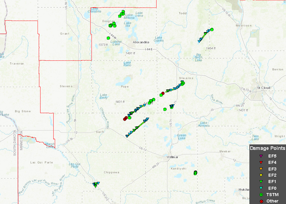
Tornado #5 and #6 hit our area during the overnight storm.
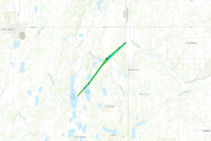
Tornado #5
Stearns County near Elrosa

Date 9/20/2017
Time (Local) 12:46 AM – 12:56 AM CDT
EF Rating EF-1
Est. Peak Winds 95 mph
Path Length 9.2 miles
Max Width 440 yards
Injuries/Deaths None
Summary:

This tornado touched down in a field and soon hit a farm, destroying several outbuildings. It moved through numerous fields, and hit three more farms and destroyed more sheds.
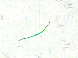


Tornado #6
Todd County north of Burtrum, west of Swanville

Date 9/20/2017
Time (Local) 1:04 AM – 1:11 AM CDT
EF Rating EF-1
Est. Peak Winds 95 mph
Path Length 6.8 miles
Max Width 440 yards
Injuries/Deaths None
Summary:

This tornado touched down just east of Big Swan Lake, where it hit one house, then moved across the northern end of Long Lake, hitting more homes, then after moving over fields and woods, hit the eastern end of Little Swan Lake, including the
community of Pillsbury. More homes were damaged, including one that was pushed off its foundation. After leaving Pillsbury, the tornado moved through more fields and woods. It dissipated just as it reached the Todd-Morrison County line, about two miles north of Swanville. Downburst damage hit Swanville and areas north of Swanville.

Ironically, Melrose wasn’t classified as a tornado in spite of the extensive damage south of I-94.

Filed Under: Local Interest

Footer

Grey Eagle, MN
Current weather
-º
Sunrise-
Sunset-
Humidity-
Wind direction-
Pressure-
Cloudiness-
-
-
Forecast
Rain chance-
-
-
Forecast
Rain chance-
-
-
Forecast
Rain chance-
-
-
Forecast
Rain chance-
Little Falls weather

Copyright © 2025 · Magazine Pro on Genesis Framework · WordPress · Log in